Real places you can visit and real objects you can see in museums, connected to the books of 1 and 2 Samuel (and the matching chapters of 1 Chronicles): the prophet Samuel, King Saul, and the reign of King David. Each one is marked honestly, so you can tell solid evidence from tradition and from claims that are still argued over.
ConfirmedThe place or object is real and is clearly the one the Bible names. For a written object, such as an inscription or a scroll, it means the object is genuine and its words are read with confidence, not that every event it mentions is proven.8
Traditional siteA real place that long tradition links to the Bible, but the exact spot cannot be proven.1
DisputedInformed people disagree, or the claim rests on weak evidence.4
BackgroundShows the world the Bible describes, but does not name a Bible person or event.1
1 Samuel: Samuel, Saul and the Young David
1
The pim weight: the price for sharpening tools
1 Samuel 13:19-21
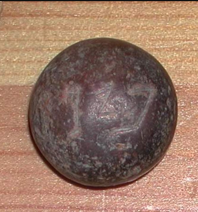
ConfirmedTop view of a small stone pim weight with its 3 Hebrew letters. Wikimedia Commons user Funhistory, Public domain.
Yet they had a file for the mattocks, and for the coulters, and for the forks, and for the axes, and to sharpen the goads.
1 Samuel 13:21, KJV
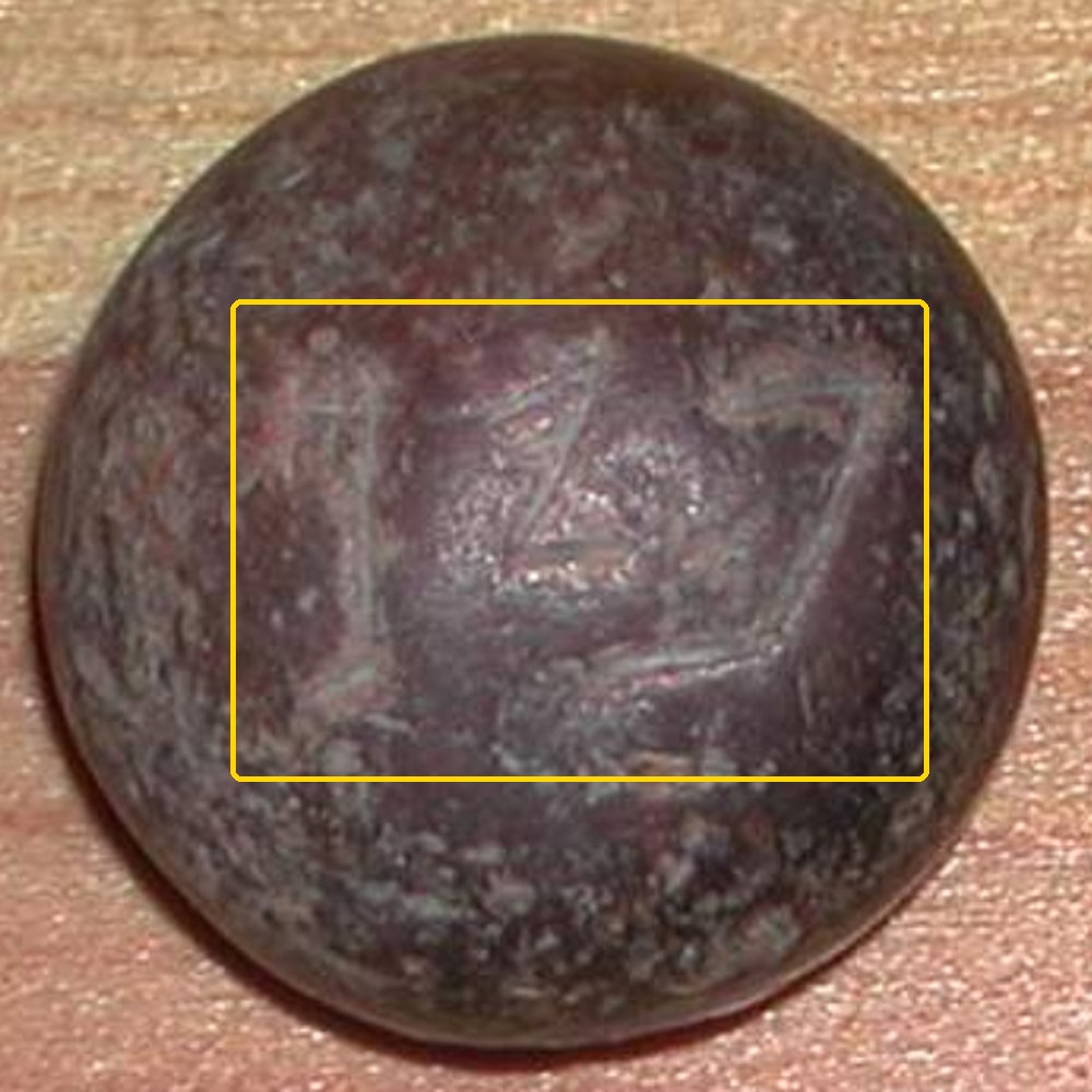
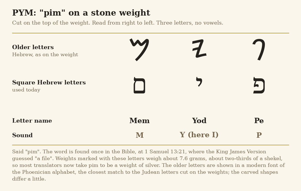
1 Samuel 13:19-21 says the Philistines kept Israel from having smiths, so Israelites had to go to the Philistines to sharpen their farm tools. The Hebrew text gives the price with the word pim, which appears only here in the Bible. Translators did not know what it meant, and the King James Version guessed "a file". From the early 1900s, small polished stone weights marked with the Hebrew letters pym were found, one of them in R. A. S. Macalister's dig at Gezer. They weigh about 7.6 grams, about two-thirds of a shekel (the shekel was the main unit of weight, about 11.4 grams). So most translators now take the verse to mean that the charge for sharpening was a pim, a small weight of silver. The photo below marks the three letters on the top of a pim weight, and the chart shows them letter by letter.
Photo of the top of a small domed stone weight inscribed "pim". The yellow box, added for this page, marks the three faint letters PYM cut into the top; they read from right to left. This weight is in a private collection and has no recorded find spot. Funhistory, via Wikimedia Commons, Public domain.Chart of the three letters PYM, said "pim", in the older Hebrew letters and in the square letters used today, with each letter's name and sound. Chart made for this page, free to reuse.
Where it is today
Pim weights belong to a larger set of inscribed weights from the kingdom of Judah. Of the 434 such weights listed by the scholar Raz Kletter, a good number come from digs, almost all within the area of Judah. The one in the photo has no recorded find spot.
Date
The weights: from the time of the kings of Judah. Most dated examples of these inscribed weights come from the 600s BC; one source gives the 800s to 600s BC for pim weights. The Bible sets this story in Saul's reign, in the 1000s BC.
Why this label: The object and the word are real: the inscribed pym weights show that pim was a real weight of about two-thirds of a shekel, which explains the verse. Most of the weights found so far are 300 years or more later than Saul, so they show the word was used in the time of the kings, not the exact price paid in Saul's day.
Good to know
Early-text view: William Dever has argued that a writer living centuries after these weights went out of use could not have known the word, so the verse must come from a time when pim weights were still in use, under the kings.
Caution: Most dated weights of this kind come from the 600s BC. They show the word belongs to the time of the kings of Judah. On their own they cannot show that it was already used in Saul's time, though a weight name can be older than the oldest weights that happen to survive.
Translations: Since the weights were found, newer translations put "pim" in the verse, for example the New King James Version (1982).
Khirbet Qeiyafa: a walled town above the Valley of Elah
1 Samuel 17:52 · Joshua 15:36
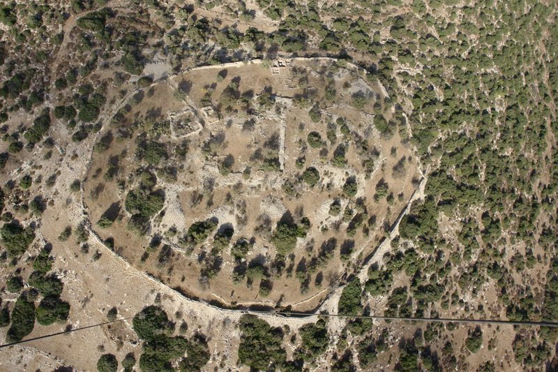
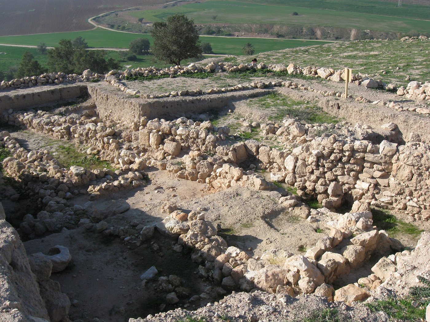
DisputedAir view of the town wall of Khirbet Qeiyafa, 2008. Skyview Photography Ltd, via Wikimedia Commons, CC BY-SA 3.0.
And the men of Israel and of Judah arose, and shouted, and pursued the Philistines, until thou come to the valley, and to the gates of Ekron. And the wounded of the Philistines fell down by the way to Shaaraim, even unto Gath, and unto Ekron.
1 Samuel 17:52, KJV
Khirbet Qeiyafa is a hilltop ruin on the north side of the Valley of Elah, where 1 Samuel 17 sets David's fight with Goliath. Yosef Garfinkel of the Hebrew University and Saar Ganor of the Israel Antiquities Authority dug there in 7 seasons, from 2007 to 2013. They found a small town (about 2.3 hectares) inside a wall of huge stones, with 2 gates. The diggers' carbon-14 tests on burnt olive pits (a lab method that dates once-living material) place the town at about 1020 to 980 BC. The diggers link it to Shaaraim (spelled Sharaim in Joshua 15:36 in the KJV), a name that can mean "two gates", which 1 Samuel 17:52 places on the road the Philistines fled along. In 2008 they also found an ostracon (writing in ink on a piece of broken pottery) with 5 lines of text in an early form of the alphabet.
Where it is today
Near Beit Shemesh, about 30 km south-west of Jerusalem, Israel. The ostracon is kept at the Israel Museum, Jerusalem; check before a visit whether it is on show.
Date
The walled town: about 1020 to 980 BC by the diggers' dating. Critics allow a wider range, about 1050 to 915 BC. Later buildings from the 300s and 200s BC and a Byzantine farmhouse (about AD 300 to 600) lie on top.
Why this label: The site, its wall, its gates and its carbon dates are real and fully published. Who built and ran the town, and whether it is the Shaaraim of the Bible, are strongly debated among leading archaeologists.
Good to know
The diggers: Garfinkel and Ganor say the town plan (houses built against the town wall), the lack of pig bones and the lack of small clay figures used in worship match later towns of Judah. They point to the massive wall, the 2 gates, a large central building, a storehouse, storage jars with marked handles, and writing. They hold that a strong walled town this early shows an organized kingdom of Judah in David's time, and they note that no other town of this period is known to have 2 gates.
Amihai Mazar: Mazar of the Hebrew University says a central authority must have planned this town, and he rejects the idea that it was Canaanite, because no Canaanite town is known with this plan or these walls. He sees David's kingdom as a "tribal state" of the 900s BC: a kingdom built on tribes, which arose while the Canaanite towns were weak and the number of Israelites in the hills was growing. In his view David's own abilities and a small but effective army may have let him build a real military and political power over large parts of the land, though smaller than the Bible's description suggests. He also says archaeology alone cannot settle the question, because archaeologists disagree on how to read the evidence.
Low-dating view: Israel Finkelstein of Tel Aviv University moves many buildings once dated to David and Solomon about 100 years later and sees David as a small local ruler. With Alexander Fantalkin (2012) he argued that Qeiyafa more likely belonged to an early northern Israelite kingdom, which Finkelstein links with Saul, and they criticized how the dig was done and how its finds were read. In 2017 they added that many features of the finds point to the north rather than to Judah. They also said the rebuilt south gate goes beyond the remains actually found; Garfinkel answers that more than 80 percent of that gate survives. In 2015 Finkelstein and Eli Piasetzky also questioned how the carbon dates had been combined.
Other readings: Nadav Na'aman and Ido Koch see a Canaanite town, and Na'aman has also suggested a tie to Philistine Gath. Yehuda Dagan places Shaaraim at a different ruin, and Na'aman doubts that the name means "two gates" at all.
The ostracon: Scholars still disagree on how to read it and even on its language. Readings range from a Hebrew text about justice for widows and orphans to a simple list of names.
1 Samuel 17:1-3 · 1 Samuel 17:19 · 2 Chronicles 11:7-9
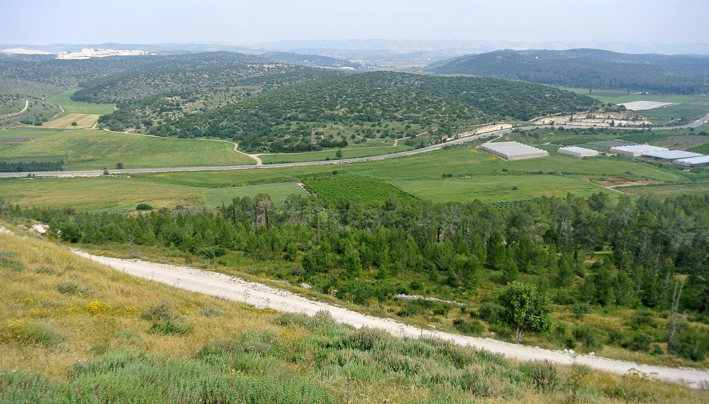
ConfirmedThe Valley of Elah seen from the top of Tel Azekah. Wilson44691, via Wikimedia Commons, CC0.
And Saul and the men of Israel were gathered together, and pitched by the valley of Elah, and set the battle in array against the Philistines.
1 Samuel 17:2, KJV
1 Samuel 17 says the Philistines camped "between Shochoh and Azekah", Saul's army camped by the valley of Elah, and the valley lay between the two armies. The Valley of Elah is a broad, flat valley in the Shephelah, the low hills between the coast and the Judean mountains. Above it stand 2 tells (hills built up from the ruins of towns built one on top of another) identified as Socoh (Tel Socho, Arabic Khirbet Shuweikeh) and Azekah (Tel Azekah, Arabic Tell Zakariya). Since 2012 a Tel Aviv University team, the Lautenschläger Azekah Expedition led by Oded Lipschits with Yuval Gadot and Manfred Oeming, has been digging at Azekah.
Where it is today
Israel, near Beit Shemesh, about 30 km south-west of Jerusalem. Tel Azekah is in a public park with a lookout over the valley. Tel Socho is about 4 km to the south-east.
Date
Both towns go back to the Bronze Age. The Bible sets the battle in Saul's reign, in the 1000s BC. The Azekah dig found a Canaanite town destroyed about 1130 BC.
Why this label: The valley is placed by its towns. Socoh keeps its old name in the Arabic Shuweikeh, and the name Socoh also appears on royal jar-handle stamps of the kingdom of Judah, though there were 2 towns named Socoh in Judah and the stamps may mean the other one. Azekah is broadly agreed to be Tel Azekah, and an Assyrian text and a letter found at Lachish also name the town. There is no inscription naming the valley itself, and its Arabic name, Wadi es-Sunt, is different.
Good to know
The battle: No object or inscription from the valley names David, Goliath or the battle. What the Azekah dig has found so far tells us about an earlier Canaanite town, not about the fight.
Later-writer view: Yigal Levin suggested the story was written down centuries later by someone who knew the area, and that the "trench" (Hebrew ma'gal, a camp, 1 Samuel 17:20) may echo the round walled town at Khirbet Qeiyafa. Garfinkel's team answered that the word means a military camp, not a walled town.
Where Azekah was: Soon after his dig began, Garfinkel suggested Khirbet Qeiyafa might be Azekah, but most scholars still place Azekah at Tel Azekah.
Gath, Goliath's city, and the sherd with "Goliath-like" names
1 Samuel 17:4 · 1 Samuel 21:10 · 2 Kings 12:17
ConfirmedDug-out stone walls of ancient buildings at Tell es-Safi (Tel Zafit), Gath, 2010. Wikimedia Commons user Ori~, Free to use with credit (Commons Attribution licence).
And there went out a champion out of the camp of the Philistines, named Goliath, of Gath, whose height was six cubits and a span.
1 Samuel 17:4, KJV
1 Samuel 17:4 says Goliath came from Gath, one of the 5 main Philistine cities. Gath is widely identified with Tell es-Safi ("the white mound"; a tell is a hill built up from the ruins of towns built one on top of another), dug by Aren Maeir of Bar-Ilan University since 1996. In 2005 the team found an ostracon (a piece of broken pottery with writing on it) with 7 letters in an early form of the alphabet, read as 2 names, alwt and wlt. Maeir said these names are like the name Goliath in form, and that they show names of this kind were used at Gath, but that the chance they refer to the Goliath of the Bible is "small if non-existent". The digs also show that Gath in the 900s and 800s BC was very large: Bar-Ilan University calls it the largest city in the land at that time.
Where it is today
Tel Zafit National Park, Israel, between Ashkelon and Beit Shemesh. Where the inscribed sherd is kept or shown today could not be confirmed.
Date
People lived on the site from before 4000 BC. The inscribed sherd: around 950 BC (the dating has some leeway), found below a thick layer of destruction. Gath was destroyed about 830 BC, a destruction the diggers link to Hazael of Aram (2 Kings 12:17).
Why this label: Most scholars agree that Tell es-Safi is Gath, Goliath's home city, though no inscription found there names the city; William Albright once objected because it lies only 8 km from Ekron. The inscribed sherd itself is only background: it shows that names of this type were used at Gath, not that the Goliath of the Bible lived.
Good to know
Common mistake: News reports in 2005 sometimes called it the "Goliath inscription". The excavator himself said it does not name the Goliath of the Bible, and it is dated some decades after the time the Bible gives for David and Goliath.
Size of Gath: A very large and strong Gath in the 900s BC fits the Bible's picture of Gath as a leading Philistine city in the time of Saul and David. It tells us nothing about Goliath himself.
Earlier page: The Philistine temple found at Gath is covered on the Joshua, Judges and Ruth page.
1 Samuel 31:10-12 · 1 Chronicles 10:10 · Judges 1:27
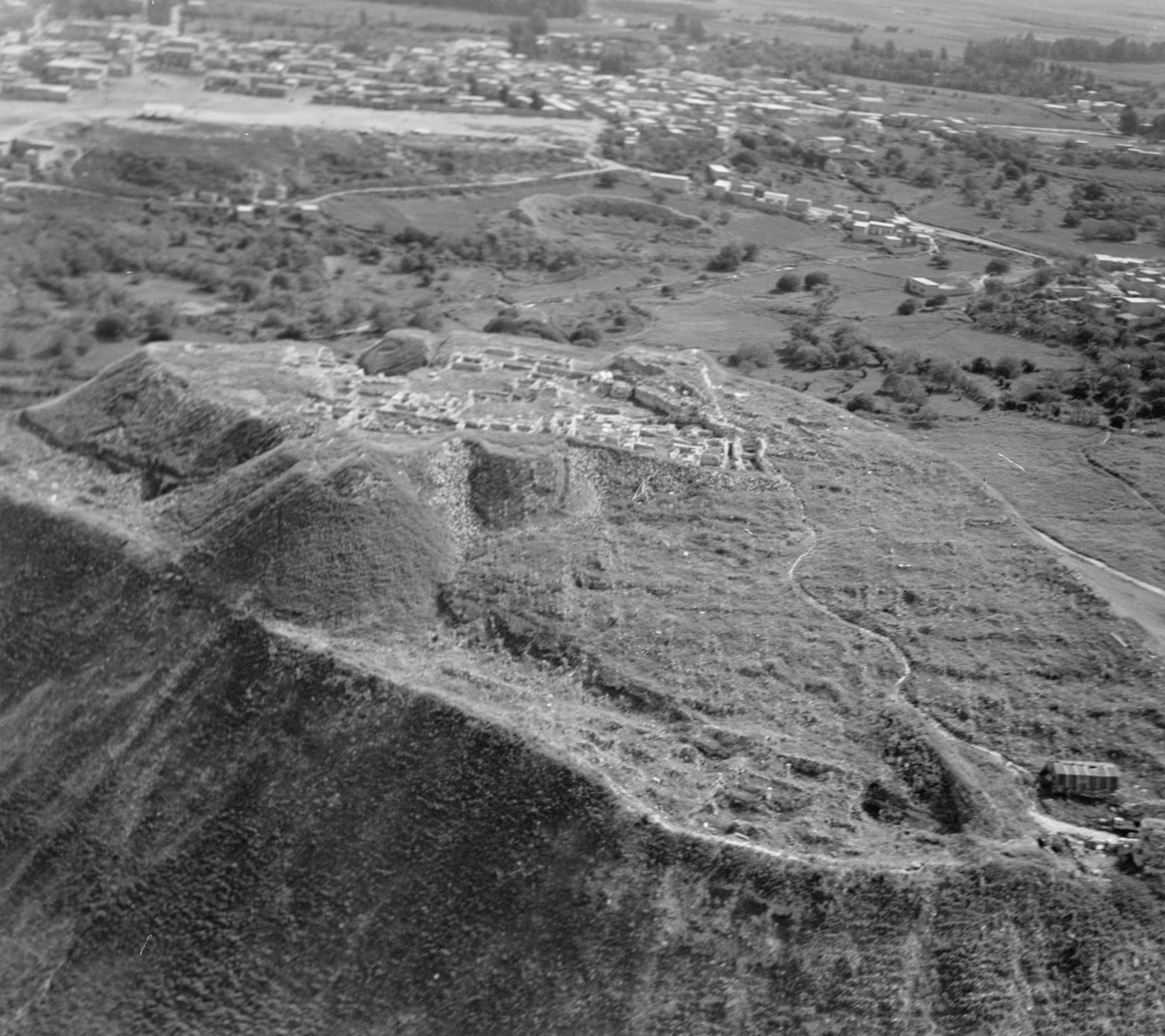
ConfirmedAir view of the mound of Beth-shan (Tell el-Husn) in 1937, with the excavated buildings on top and the town of Beisan behind. American Colony (Jerusalem) Photo Department. G. Eric and Edith Matson Photograph Collection, Library of Congress Prints and Photographs Division, LC-DIG-matpc-17062, No known restrictions on publication (Library of Congress statement).
And they put his armour in the house of Ashtaroth: and they fastened his body to the wall of Bethshan.
1 Samuel 31:10, KJV
1 Samuel 31:10-12 says the Philistines fastened Saul's body to the wall of Bethshan, and men of Jabesh-gilead came by night to take it down. Beth-shan is the large ruin mound Tell el-Husn at modern Beit She'an, where the Jordan and Jezreel valleys meet. Digs by the University of Pennsylvania (1921 to 1933) and by Amihai Mazar of the Hebrew University (1989 to 1996) found about 18 towns built one on top of another. They include a major Egyptian base with temples and stone monuments of the pharaohs Seti the First and Ramesses the Second. After the Egyptians left in the 1100s BC, a Canaanite town stood on the mound in the period the Bible gives for Saul. Below the mound lie the streets, theatre and baths of the Roman and Byzantine city of Scythopolis.
Where it is today
Beit She'an National Park, northern Israel. Many Egyptian finds are in the Rockefeller Museum, Jerusalem, and some are in the Penn Museum, Philadelphia.
Date
First settled about 5000 BC or earlier. Egyptian base from the 1400s BC to about 1130 BC. The Bible's account of Saul's death is set in the late 1000s BC. The Roman and Byzantine city grew from 63 BC. It lasted into the early Islamic period and was wrecked by an earthquake in AD 749.
Why this label: The old name lives on in the Arabic Beisan and the Hebrew Beit She'an, and Egyptian records also name the town. The place is certain; no find refers to Saul.
Good to know
Philistines at Beth-shan: Amihai Mazar found no sign that Philistines lived there in the 1000s BC. He suggests the story at most reflects a Philistine raid into the valley rather than a long stay. Others note that a passing Philistine force could have done what the verse describes without settling there.
Temple names: In 1926 the Penn excavator Alan Rowe called 2 temples on the mound the "temple of Dagon" and the "house of Ashtaroth" because of 1 Samuel 31:10 and 1 Chronicles 10:10. His own finds pointed to other gods. A stone monument found in the northern temple showed a goddess he called Antit-Ashtoreth, and he took the southern temple to belong to the god Resheph. No inscription there names Dagon.
Later dating: Amihai Mazar suggests that these 2 temples belong to the Canaanite town of the 1000s BC. So temples did stand on the mound in the time the Bible gives for Saul, but nothing found in them refers to Saul or to the Philistines.
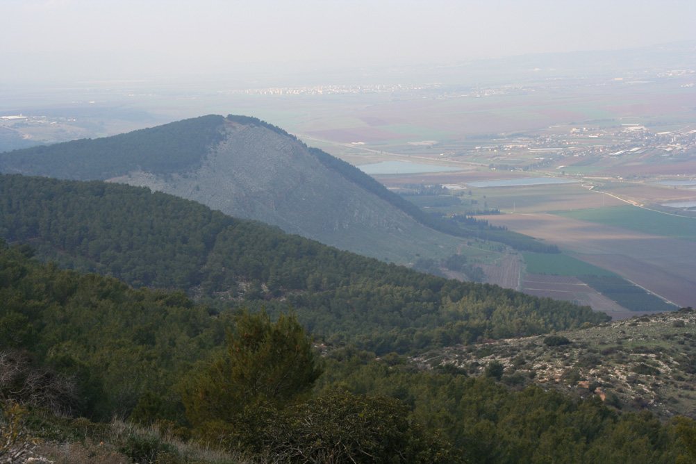
ConfirmedPart of the Gilboa ridge, with the farmland of the valley floor below. Beivushtang at English Wikipedia, via Wikimedia Commons, CC BY-SA 3.0.
Now the Philistines fought against Israel: and the men of Israel fled from before the Philistines, and fell down slain in mount Gilboa.
1 Samuel 31:1, KJV
1 Samuel 28:4 says Saul camped on Gilboa while the Philistines camped at Shunem. 1 Samuel 31 says Israel was beaten there and Saul and 3 of his sons died. In 2 Samuel 1:21 David mourns: "Ye mountains of Gilboa, let there be no dew". Mount Gilboa is a curved ridge on the south-east side of the Jezreel Valley, above the Harod Valley and about 7 km from Beit She'an, where the Philistines hung Saul's body. Its highest peak, Mount Malkishua, is about 538 metres above sea level.
Where it is today
Northern Israel, along the south-east edge of the Jezreel Valley. Nature reserves and a scenic road run along the ridge, and the purple Gilboa iris flowers there from late February to late March.
Date
The Bible sets the battle at the end of Saul's reign, in the late 1000s BC.
Why this label: The ridge fits the Bible's own map: it faces Shunem across the valley and lies close to Jezreel and Beth-shan. The old name also seems to survive in the Arabic name of the ridge, Jabal Jalbu', and in the village of Jalbun on one of its side ridges. No find marks the battlefield itself.
Good to know
The name: In Arabic the ridge is called Jabal Fuqqu'a or Jabal Jalbu'. Older reference books say the village of Jalbun (Jalbon) on the ridge seems to keep the ancient name, and some link it to a village "Gelbus" listed by Eusebius about AD 300.
The battle: No weapons, graves or other remains of Saul's last battle have been found, and the exact spot on the slopes is not known.
Later history: The Battle of Ain Jalut (1260), where the Mamluks of Egypt stopped the Mongols, was fought at the foot of the same ridge.
The pass of Michmash, Jonathan's climb, and a 1918 story
1 Samuel 13:23 · 1 Samuel 14:4-14 · Isaiah 10:28-29
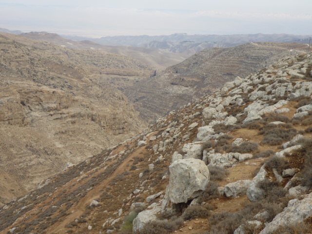
ConfirmedNahal Michmas (Wadi es-Suweinit), the gorge of the pass of Michmash. Daniel Ventura, via Wikimedia Commons, CC BY-SA 4.0.
And between the passages, by which Jonathan sought to go over unto the Philistines' garrison, there was a sharp rock on the one side, and a sharp rock on the other side: and the name of the one was Bozez, and the name of the other Seneh.
1 Samuel 14:4, KJV
1 Samuel 13 and 14 tell how the Philistines camped at Michmash, and Jonathan and his armour-bearer crossed "the passage of Michmash" between 2 sharp rocks named Bozez and Seneh, climbed up and surprised the Philistine outpost. Michmash is the village of Mukhmas north-east of Jerusalem, which keeps the old name. The pass is the deep, steep-sided valley just south of it, Wadi es-Suweinit (in Hebrew, Nahal Michmas), with Jaba (Bible Geba) on the other side. Isaiah 10:28-29 also names Michmash and "the passage".
Where it is today
Near the village of Mukhmas, about 13 km north-north-east of Jerusalem. Access is limited, so check before planning a visit.
Date
The Bible sets the story early in Saul's reign, in the 1000s BC. The British official history says British troops occupied Mukhmas on 14 February 1918.
Why this label: Michmash is broadly agreed to be Mukhmas, which keeps the ancient name, and the gorge beside it fits the story. The 2 rocks Bozez and Seneh have not been matched to exact cliffs, and no find marks Jonathan's climb.
Good to know
The wartime story: Major Vivian Gilbert served with the 180th Brigade of the 60th (London) Division. In his book The Romance of the Last Crusade (1923), he tells this story. Before a planned attack on Mukhmas, an unnamed brigade major read 1 Samuel 13 and 14 by candlelight and woke his brigadier. Scouts then found the pass lightly held by Turkish troops. The general changed the plan, and one company went through the pass at night and took the village by surprise. Gilbert writes "We passed between Bozez and Seneh", but he does not make clear whether he himself was with that company.
Confirmed by other records: The British official history by Cyril Falls (1930) says the 60th Division occupied Mukhmas on 14 February 1918, before the advance on Jericho. The war reporter W. T. Massey (1919) says a brigade of the 60th Division was ordered to capture it.
Rests on Gilbert alone: The Bible reading, the scouts, the change of plan and the night march through the pass. Neither Falls nor Massey describes how the village was taken, the brigade major is never named, and this review found no other record that confirms the story. Gilbert's book grew out of public talks he gave after the war.
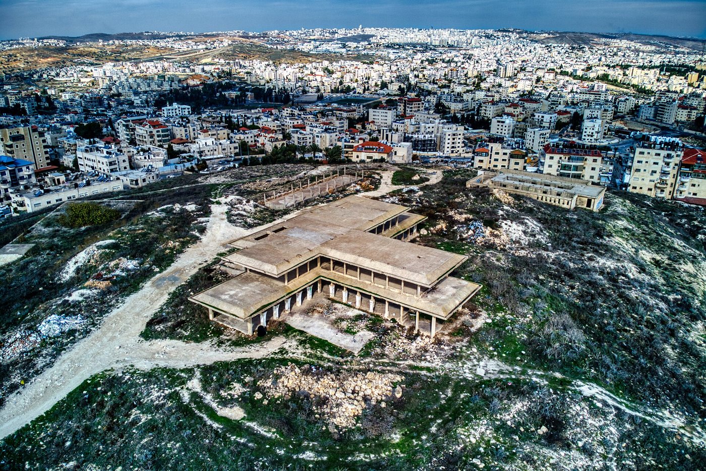
DisputedAir view of the unfinished palace of King Hussein of Jordan on the summit of Tell el-Ful, 2022. Hagai Agmon-Snir, via Wikimedia Commons, CC BY-SA 4.0.
And Saul also went home to Gibeah; and there went with him a band of men, whose hearts God had touched.
1 Samuel 10:26, KJV
Gibeah ("hill") was Saul's home town and base. 1 Samuel 10:26 says Saul "went home to Gibeah", and later verses call it "Gibeah of Saul". Most scholars have placed it at Tell el-Ful, a hilltop about 5 km north of the Old City of Jerusalem. William F. Albright dug there from 1922, and Paul Lapp in 1964. They found remains of a strong stone building with a corner tower, which they took to be a fort built by Saul.
Where it is today
Northern Jerusalem. The summit is taken up by an unfinished palace that King Hussein of Jordan began building in the 1960s. Work stopped in 1967 and it was never finished.
Date
People lived there at times from about the 1100s BC to about 100 BC. The Bible sets Saul's reign in the 1000s BC.
Why this label: Tell el-Ful is a real ancient site and is still the most common choice for Gibeah of Saul. But both the identification and the date of its "fortress" are now seriously questioned by informed scholars.
Good to know
Traditional view: The Jewish historian Josephus (about AD 75) places "Gabaothsaul" about 30 stadia (an old Greek measure; about 5 to 6 km) north of Jerusalem, and Jerome's account of the pilgrim Paula's journey (about AD 400) also fits Tell el-Ful. Albright and Lapp held that Saul built the first fort there.
Doubting view: Israel Finkelstein (2011) argues there was no large fortress at the site in Saul's time. He dates the tower to the 600s BC, late in the time of the kings of Judah, when he thinks it was built as an Assyrian watchtower, one of a ring of forts guarding the northern road to Jerusalem, and he rejects the identification with Gibeah. He offers a different ancient name for the site only as a tentative suggestion.
Other option: Edward Robinson and some others placed Saul's Gibeah at Jaba, but Jaba is now usually taken to be Geba, a different town.
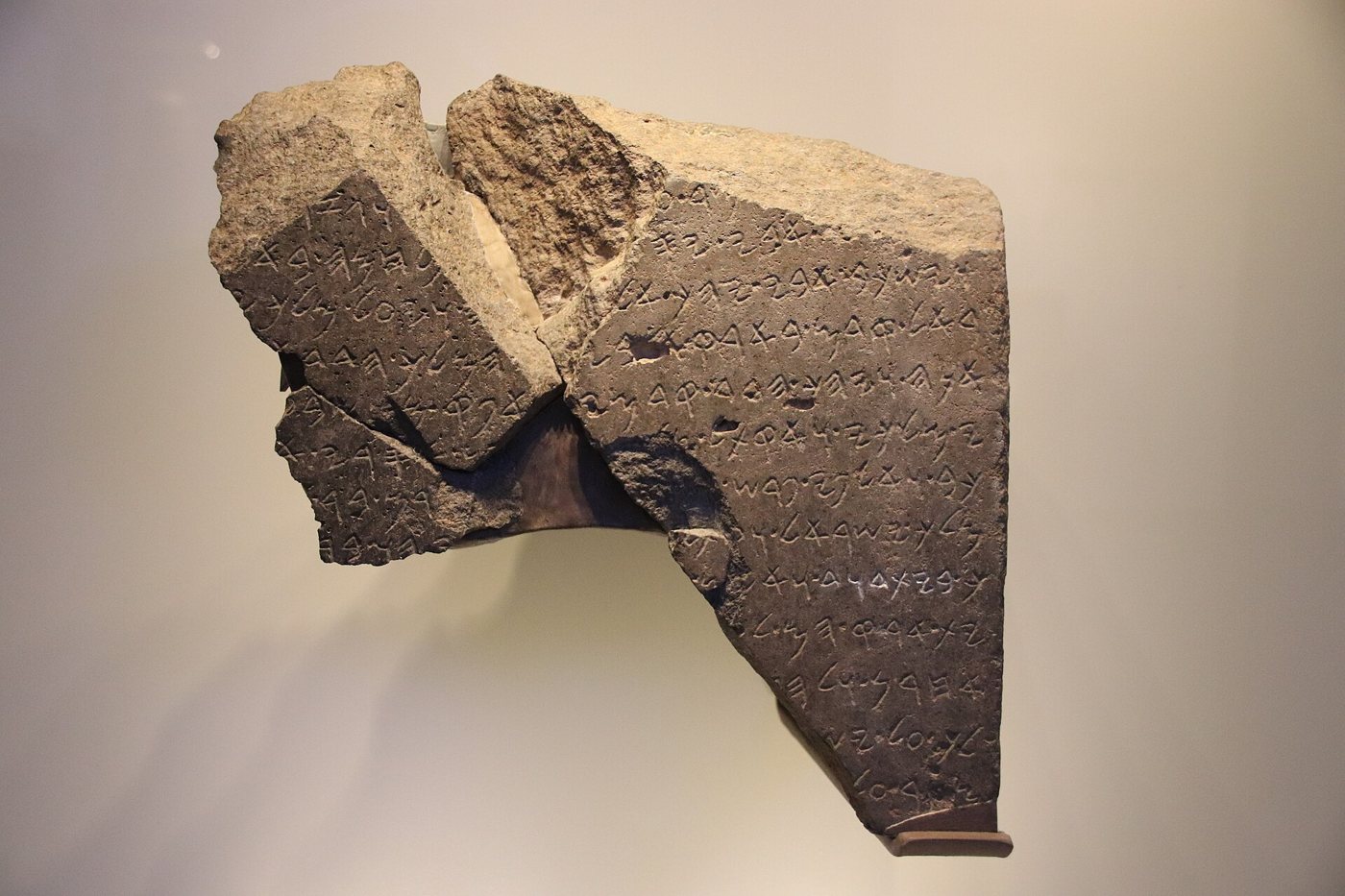
ConfirmedThe Tel Dan Stele on display. Gary Todd, via Wikimedia Commons, CC0.
And thine house and thy kingdom shall be established for ever before thee: thy throne shall be established for ever.
2 Samuel 7:16, KJV
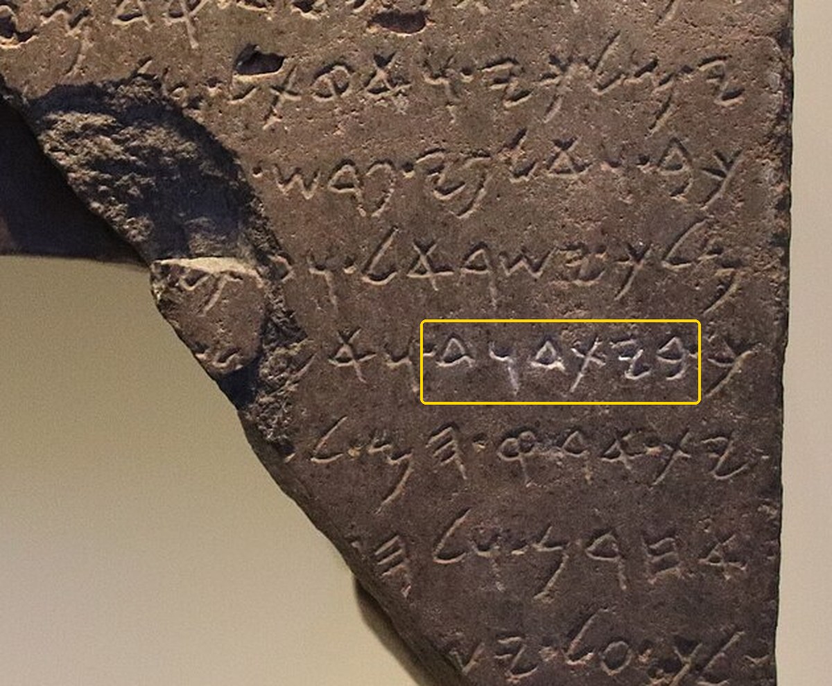
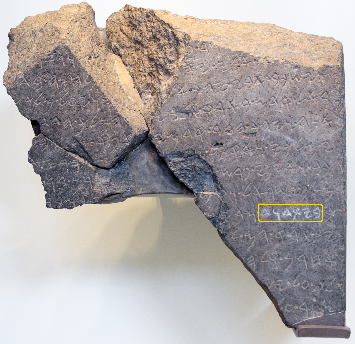
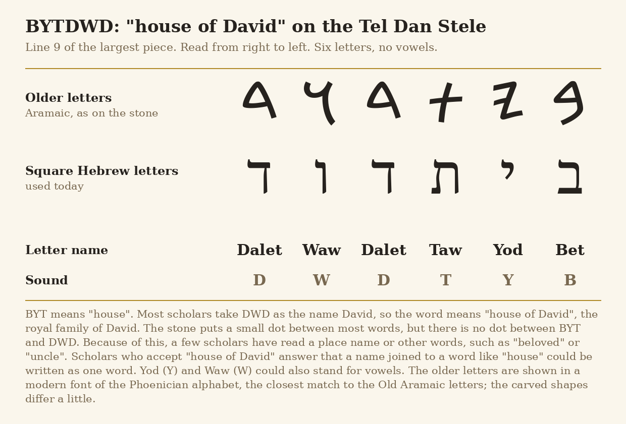
A broken stele (a carved stone slab set up to record an event) of basalt, a hard dark volcanic rock. It was found at Tel Dan, the ruin mound of the city of Dan in northern Israel: the largest piece in July 1993 and two smaller pieces in June 1994. It is written in Aramaic, the language of Aram (ancient Syria), by a king of Aram, usually taken to be Hazael of Damascus (2 Kings 8:28). The king boasts that he defeated a "king of Israel" and a king of "the house of David" (written bytdwd). It is the earliest widely accepted mention of David outside the Bible, and it comes from one of Israel's enemies. The photos below mark the word bytdwd on the stone, and the chart shows its six letters.
Photo of the original Tel Dan Stele in the Israel Museum, Jerusalem: a close-up of the right-hand part of the largest piece. The writing reads from right to left. The yellow box, added for this page, marks the six letters BYTDWD, "house of David", at the start of line 9. Just to the right of the box, at the edge of the stone, is the last letter of the word "king", carried over from line 8. The word appears once on the stone, so there is one box. Gary Todd, via Wikimedia Commons, CC0.Photo of the original stone in the Israel Museum, showing all three pieces (the largest piece is on the right). The yellow box, added for this page, shows where BYTDWD, "house of David", sits on line 9. In this photo the letters of that word look whiter than the rest; Wikipedia's caption for the photo says they are highlighted in white. Oren Rozen, via Wikimedia Commons, CC BY-SA 4.0.Chart of the six letters of BYTDWD, "house of David", in the older letters and in the square Hebrew letters used today, with each letter's name and sound. The note explains the missing word dot and the minority readings. Chart made for this page, free to reuse.
Where it is today
The Israel Museum, Jerusalem (from the collection of the Israel Antiquities Authority). Check before a visit that it is on show.
Date
Most scholars date it to the second half of the 800s BC, probably soon after 841 BC, roughly 150 years after David. Experts put the possible range at about 870 to 750 BC, and a few scholars have argued for later dates.
Why this label: The pieces were found in a controlled dig, and most scholars accept that bytdwd means "house of David", a royal line named after David. It confirms that a foreign king knew Judah's kings as David's line. It does not describe David's own life or reign.
Good to know
Early doubts: A few scholars at first called it a forgery (Cryer and Lemche). That claim faded because the pieces came from a proper excavation, not from the antiquities market, and the stone is now widely accepted as genuine. Others read bytdwd as a place name or as other words such as "beloved" or "uncle" (Philip Davies, Niels Peter Lemche and others). Most scholars read it as "house of David", but a minority still do not. They point out that the stone uses dots to separate words elsewhere but has none between byt ("house") and dwd. Others answer that a name joined to a word like "house" could be written as one word, so a missing dot means little.
What it shows: Within about 150 years of David, an enemy king called Judah's ruling family "the house of David".
What it cannot show: It says nothing about how large or rich David's kingdom was. The names of the two kings it claims to have killed are partly broken off. The Israel Museum and many scholars read them as Joram of Israel and Ahaziah of Judah, but others doubt this reading. If that reading is right, the two accounts differ: the Bible says Jehu killed those two kings (2 Kings 9:24-27), while the stone gives the credit to the Aramean king. Scholars explain this in different ways: the Aramean king may have seen Jehu as acting for him, he may simply have claimed the credit for Jehu's deed, or the Bible may give Jehu the credit for what the Arameans did.
Mesha Stele: In 1994 Andre Lemaire proposed that line 31 of the Mesha Stele also reads "house of David", but the letters there are damaged and scholars still disagree.
The City of David: the Stepped Stone Structure and "David's palace"
2 Samuel 5:7 · 2 Samuel 5:9 · 2 Samuel 5:11
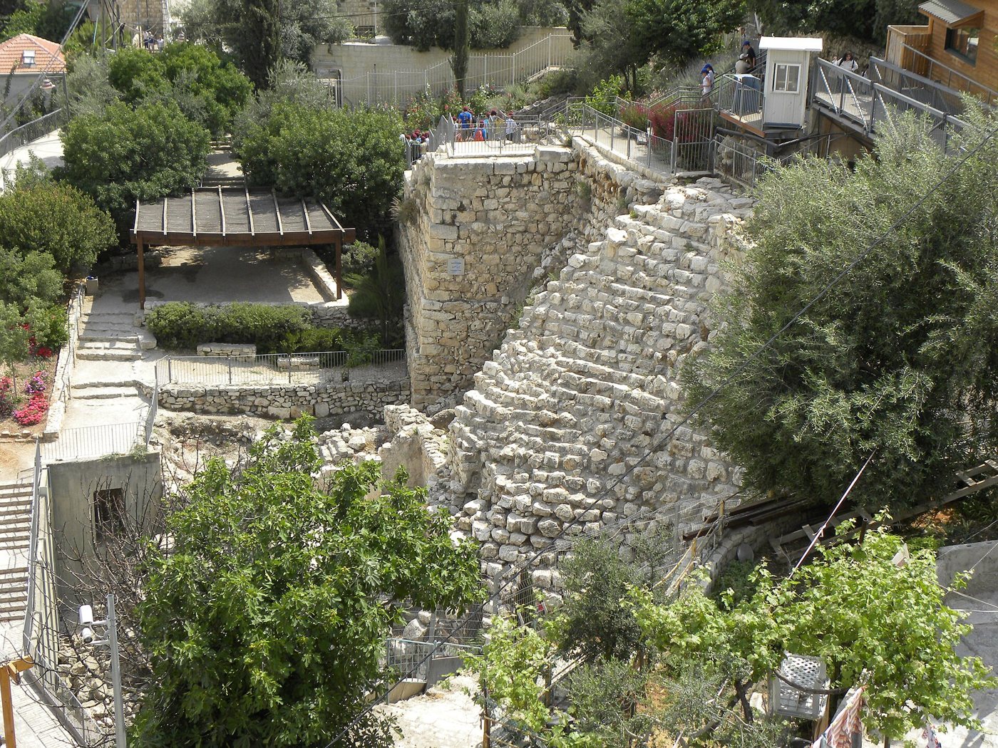
DisputedThe Stepped Stone Structure on the eastern slope of the City of David. Ian Scott, via Wikimedia Commons, CC BY-SA 2.0.
So David dwelt in the fort, and called it the city of David. And David built round about from Millo and inward.
2 Samuel 5:9, KJV
The oldest part of Jerusalem is a narrow ridge just south of the Temple Mount, now called the City of David. On its eastern slope stands the Stepped Stone Structure, a curved stone slope about 18 metres high built over earlier terraces. Above it, Eilat Mazar dug from 2005 and found massive walls she called the "Large Stone Structure". She proposed that this was the house that Hiram's workers built for David (2 Samuel 5:11), and that the stepped slope held it up, perhaps the "Millo" of 2 Samuel 5:9.
Where it is today
City of David archaeological park, just south of the Old City walls, Jerusalem. The Large Stone Structure lies under the site's visitor centre. The Stepped Stone Structure is on the eastern slope.
Date
Debated. Views range from about the 1100s BC (before David), to the 900s BC (David's time), to later rebuilding, with some upper parts perhaps as late as the 100s BC.
Why this label: Everyone agrees the walls are real and old. Experts disagree on when they were built, whether they belong to one building, and whether anything here can be tied to David himself.
Good to know
Eilat Mazar: The newest pottery found under the walls dates from the 1100s and 1000s BC, so she held that the building was put up about 1000 BC. She also pointed to its great size, to its place outside the walls of the older Jebusite town, and to finds inside such as Phoenician-style ivory inlays and an imported jug. She identified it as David's palace.
Middle view: Amihai Mazar agrees with Kenyon, Shiloh, Cahill, Steiner and Faust that the stepped slope and the big walls formed one huge complex that stood in the 900s BC or a little earlier. He has suggested it may first have been the Jebusite fortress David captured. He sees David's Jerusalem as small but strong, by one estimate about 1,000 people. Jodi Magness also thinks the building was first put up in the 1100s BC, before David, and was still in use in the 800s BC.
Low-chronology view: Israel Finkelstein, Ze'ev Herzog, Lily Singer-Avitz and David Ussishkin (2007) argued that the walls Eilat Mazar found are not one building, and that the best-built walls may date from as late as the 100s BC. In their view the lower part of the stepped slope may date to the 800s BC and its upper part to the 100s BC. They said the pottery shows only that the walls were built some time after about 1000 BC and before Roman times, and that the Bible, not the finds, guided Eilat Mazar's date. Finkelstein sees David as the leader of a small highland chiefdom (a territory led by a tribal chief), not a large state. Avraham Faust replied (2010) that the full report of the dig, published later, supports Eilat Mazar's early date.
Khirbet Qeiyafa: Yosef Garfinkel's case for an organized kingdom in David's time, and the replies to it, are set out in the Khirbet Qeiyafa entry on this page.
Newer evidence: A 2024 study of 103 radiocarbon dates (a lab method that dates once-living material) from Jerusalem found settlement from the 1100s to the 900s BC and large building projects across the city by the 800s BC. It does not settle how large David's kingdom was, so that question is still open.
The "gutter" and Warren's Shaft at the Gihon spring
2 Samuel 5:8 · 1 Chronicles 11:6
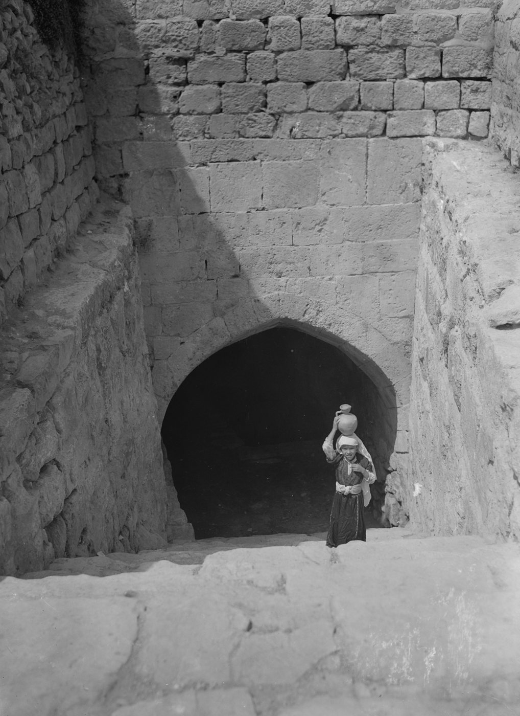
DisputedA girl carrying a water jar climbs the steps from the Gihon spring (then called the Virgin's Fountain), photographed between about 1900 and 1920. This is the spring entrance, not Warren's Shaft itself. American Colony (Jerusalem) Photo Department. G. Eric and Edith Matson Photograph Collection, Library of Congress Prints and Photographs Division, LC-DIG-matpc-12310, No known restrictions on publication (Library of Congress statement).
And David said on that day, Whosoever getteth up to the gutter, and smiteth the Jebusites, and the lame and the blind that are hated of David's soul, he shall be chief and captain. Wherefore they said, The blind and the lame shall not come into the house.
2 Samuel 5:8, KJV
2 Samuel 5:8 says David promised a reward to whoever "getteth up to the gutter" (Hebrew tsinnor) and struck the Jebusites, and 1 Chronicles 11:6 says Joab went up first. In 1867 Charles Warren found a natural vertical shaft, about 13 metres deep, linked to the Gihon spring on the eastern slope of the City of David. For more than a century many people thought this "Warren's Shaft" was the tsinnor that Joab climbed.
Where it is today
City of David archaeological park, Jerusalem. Visitors walk down the rock-cut tunnel to platforms at the top of Warren's Shaft.
Date
The shaft is a natural crack in the rock. In Reich and Shukron's view, the tunnel reached the top of the shaft only in the 700s BC. The tower guarding the spring is dated either to about 1700 BC or to about 900 to 800 BC (see below).
Why this label: The place is real, but the excavators now think the shaft was unknown and unused in David's day, while other archaeologists disagree. The meaning of the word tsinnor is also uncertain.
Good to know
New digs: From 1995 Ronny Reich and Eli Shukron concluded that the tunnel was never meant to lead to the shaft. In their view it reached the top of the shaft only by accident, when the tunnel floor was lowered in the 700s BC, nearly 300 years after David. They also found no rope marks at the top and only shallow water at the bottom, so they concluded the shaft was never used to draw water.
Other view: Many archaeologists still think the shaft was part of the early water system. Opinions also differ on when people first found the shaft: some think long before David, in the Middle Bronze Age (about 2000 to 1550 BC), others not before the 700s BC.
Spring defences: Reich and Shukron found rock-cut channels and a massive "Spring Tower" guarding the spring, which they dated to about 1700 BC, long before David. In 2017 a radiocarbon study (a lab method that dates once-living material) of soil under one corner of the tower dated its base nearly 1,000 years later, to about 900 to 800 BC. Reich replied that the samples could have been washed in by floods or could come from a later repair, and that the tower's huge stones are built like other town walls of the Middle Bronze Age, such as those at Gezer, Hebron and Shechem, not like later walls in Judah. So the date is still argued.
The word: Tsinnor may mean a pipe, channel or shaft. Some still think Joab entered by way of the water system, just not through Warren's Shaft. Others think the word has nothing to do with water at all, for example that it means the throat.
Later tunnel: Hezekiah's tunnel, cut later from the same spring, belongs to a later page.
2 Samuel 11:1 · 2 Samuel 11:14-17 · 2 Samuel 12:26-31
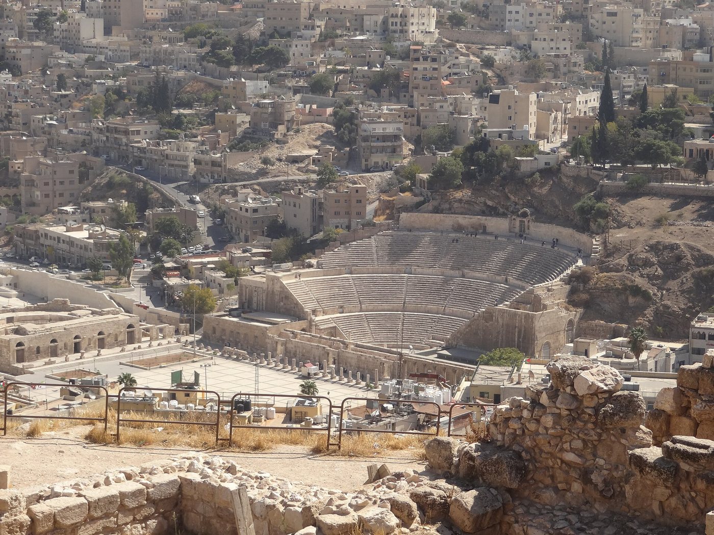
ConfirmedView from the Amman Citadel hill over the Roman theatre and the modern city, with old walls on the hill in front. Tarawneh, via Wikimedia Commons, CC BY-SA 3.0.
And it came to pass, after the year was expired, at the time when kings go forth to battle, that David sent Joab, and his servants with him, and all Israel; and they destroyed the children of Ammon, and besieged Rabbah. But David tarried still at Jerusalem.
2 Samuel 11:1, KJV
Rabbah was the royal city of the Ammonites. While Joab besieged it, David stayed in Jerusalem, took Bathsheba, and had her husband Uriah put where the fighting was hardest so that he was killed (2 Samuel 11). Joab later took "the city of waters", and David came and captured the city (2 Samuel 12:26-29). The ancient city stood on the hill now called Jabal al-Qal'a, the Amman Citadel, in the heart of Jordan's capital.
Where it is today
Amman Citadel (Jabal al-Qal'a), Amman, Jordan: an open-air site with a museum. The Amman Citadel Inscription is listed as number J 9000 of the Jordan Archaeological Museum on the Citadel; check before a visit where it is on show.
Date
People lived on the hill from the Bronze Age onward. It was the Ammonite capital in the Iron Age. The dated Ammonite finds described here come from the 800s to 600s BC: the inscription from the late 800s BC and the large building on the eastern side from the 600s BC.
Why this label: The name Rabbath Ammon lives on in the modern name Amman, and Jordan's Department of Antiquities identifies the Citadel as the Iron Age Ammonite capital. No inscription on the site names the city Rabbah, and no find there is tied to Joab's siege itself.
Good to know
The inscription: Found on the Citadel in 1961, it is a small white limestone block with 8 broken lines, the oldest known text in the Ammonite language. Many read it as words of the god Milkom (the "Milcom" of 1 Kings 11:5), but much of the text is missing, so the meaning is uncertain.
The digs: The Ammonites built a palace and a temple on the hill. Since 2024 a German and Jordanian team has been digging a large building from the 600s BC, with an older large building beneath it, on the eastern side. The team is still asking whether it was the palace of the Ammonite kings.
What you see: Most of the visible ruins, such as the Temple of Hercules and the Umayyad Palace, are much later than David.
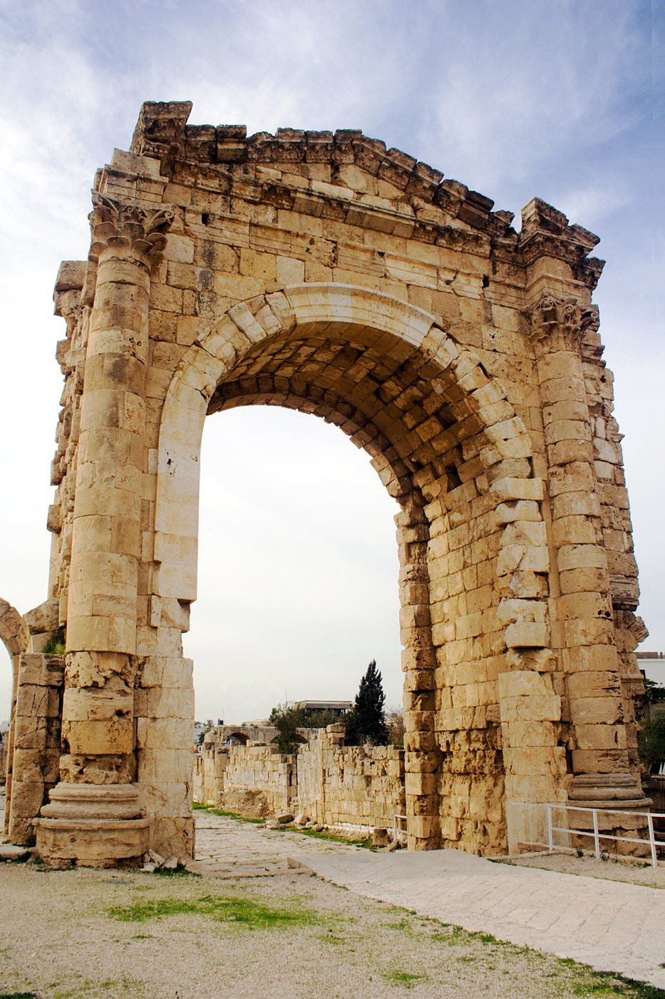
BackgroundThe Roman arch among the ruins of Tyre. David Bjorgen, via Wikimedia Commons, CC BY-SA 2.5.
And Hiram king of Tyre sent messengers to David, and cedar trees, and carpenters, and masons: and they built David an house.
2 Samuel 5:11, KJV
The Bible says Hiram king of Tyre sent cedar wood, carpenters and masons to build David a house, and later helped Solomon build the temple. Tyre, a Phoenician port city built on an island off the coast of today's southern Lebanon, is real and well known. Outside the Bible, Hiram is known only from later writers: the Jewish historian Josephus (first century AD) quotes Menander of Ephesus and Dius, who, Josephus says, drew on Tyre's own records.
Where it is today
Tyre (Sour), southern Lebanon. Its ruins are a UNESCO World Heritage Site, and most visible remains are Roman or later. Access can be limited, so check before planning a visit.
Date
Hiram reigned 34 years in the 900s BC. Estimates include about 980 to 947 BC and about 969 to 936 BC.
Why this label: Tyre is clearly the city the Bible names, and later writers who used Tyre's records name a King Hiram at this time. But no inscription from Hiram's own reign has been found, so nothing on the ground confirms his dealings with David.
Good to know
What Menander says: Hiram became king at 19, reigned 34 years, enlarged the city and built temples. Menander and Dius also say Hiram and Solomon challenged each other with riddles.
The gap: No royal or official documents from Tyre itself have been found. Menander wrote about 800 years after Hiram, and his book is lost, so we read him only through Josephus. A later king also named Hiram paid tribute to Assyria in the 700s BC; he should not be confused with this Hiram.
Dating question: Solomon's reign usually begins about 970 BC, so if Hiram became king about 980 BC, his reign overlapped only David's last years. On the later estimate (from about 969 BC), it did not overlap David's reign at all. So either the gift of cedar came late in David's reign (on the earlier estimate), or the dates need adjusting. 2 Samuel 5 tells it right after David took Jerusalem, but some scholars think that chapter groups events by subject rather than in time order. Scholars still debate the exact dates.
Tomb of Hiram: The stone tomb near Tyre called the Tomb of Hiram dates from the Persian period, centuries after him.
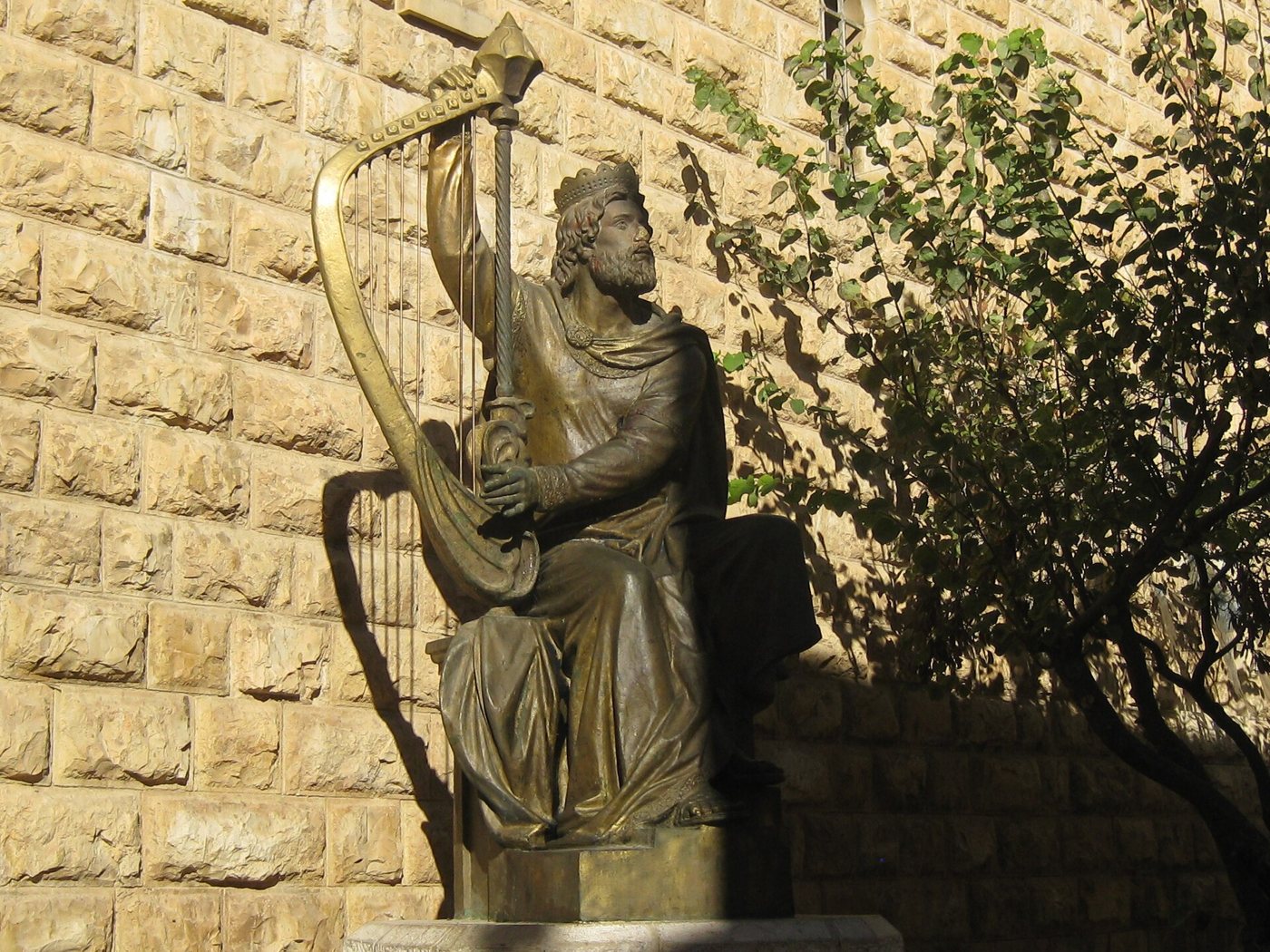
Traditional siteThe modern bronze statue of King David with his harp, near the traditional Tomb of David on Mount Zion. Shlomo Roded, PikiWiki Israel, via Wikimedia Commons, CC BY 2.5.
So David slept with his fathers, and was buried in the city of David.
1 Kings 2:10, KJV
A room on the ground floor of an old building on Mount Zion, just outside the Old City's Zion Gate, holds a cloth-covered cenotaph (an empty memorial tomb) honoured as King David's tomb. The Cenacle, the traditional room of the Last Supper, is on the floor above. The Bible says David was buried "in the city of David" (1 Kings 2:10), Nehemiah 3:16 mentions "the sepulchres of David", and Peter said David's tomb was still known in his day (Acts 2:29).
Where it is today
Mount Zion, Jerusalem, just south of the Old City walls. It is an active place of prayer, so dress modestly and check opening hours.
Date
The tradition placing David's tomb here appears from about the 800s AD. The cenotaph was made by the Crusaders (about the 1100s AD). The building is mostly medieval and rests on older walls, perhaps from the Roman or Byzantine period.
Why this label: The room has been honoured as David's tomb for over 1,000 years. But historians and archaeologists do not consider it his real burial place, and Jewish religious scholars such as Rabbi Ari Zivotofsky agree.
Good to know
Not the real tomb: The Bible places David's grave in the City of David, the small ridge to the east. In David's time this western hill was not part of the city. The name "Mount Zion" was given to this hill much later, and pilgrims then mistook it for David's Zion. In the 300s AD, David's tomb was instead pointed out in Bethlehem.
How the tradition grew: The first mention of David's tomb here dates from about the 800s AD. Around 1173 the Jewish traveller Benjamin of Tudela repeated a story of two workers who found a hidden palace with David's crown and treasure. The Crusaders set up the cenotaph that is still there.
Possible royal tombs: In 1913 Raymond Weill dug long rock-cut tombs in the southern City of David that some archaeologists think may be the royal tombs of Judah. Others think they were later water cisterns or cellars. Nothing found there names David.
 LearnAboutHim